Over the past 30 years, SPSSEG has completed over 200 projects aimed at improving salmon habitat, fish passage, and ecosystem functioning. This is only a partial list of our projects. We are in the process of adding to it as we complete new projects and as we sort through old files.
Please see our Story Map to learn more about some of our recent projects and the work we do.
Projects in Mason County have included:
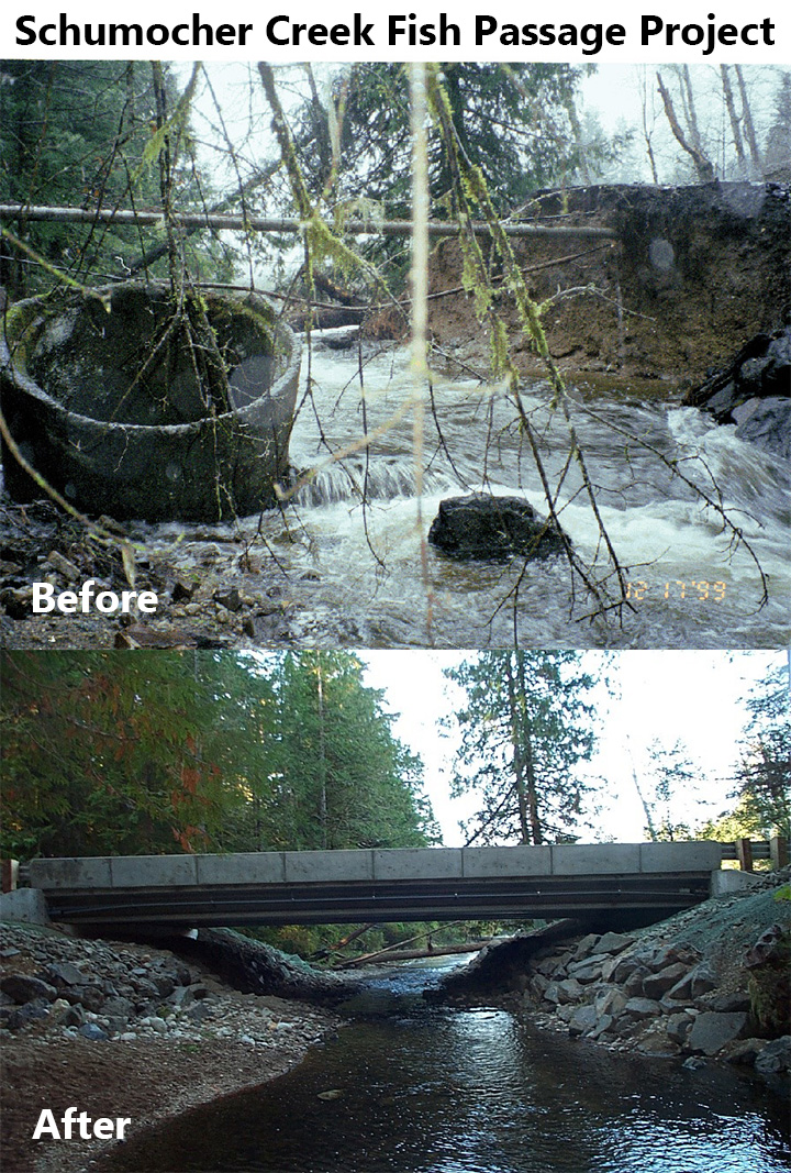
- Schumocher Creek Fish Passage Project – Replaced a road culvert that washed out during flooding with a fish-passable bridge that provided access for salmon to 3 miles of spawning and rearing habitat and a 20+ acre wetland (2000)

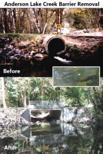
- Anderson Lake Creek Barrier Removal – Replaced a culvert that blocked fish passage with a bottomless structure, restoring salmon access to 2.1 miles of stream habitat (2001)
- Sherwood Creek Fish Passage Project – Replaced two undersized fish passage barrier culverts with steep slopes and high water velocities with a bridge that allowed migration of salmonids at all life stages, restoring salmon access to 17 miles of stream habitat (2002)

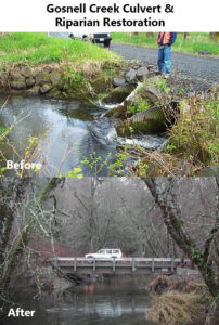
- Gosnell Creek Culvert and Riparian Restoration – Replaced two side-by-side barrier culverts with a bridge to provide passage to all salmonid life stages and allow for natural streambed migration, opening up 1.5 miles of stream habitat (2002)
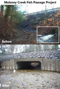
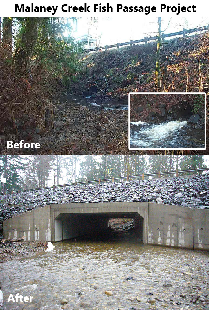
- Malaney Creek Fish Passage Project – Replaced an undersized (4’ diameter) steel pipe culvert that completely blocked fish passage with a 22’ wide concrete box culvert, restoring salmon access to 2.5 miles of stream habitat (2003)
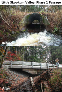
- Little Skookum Valley, Phase 1 Passage – Replaced a failing culvert with a bridge to open up fish access to 1.4 miles of stream habitat, allow for salmon migration at all life stages, streambed material transport, and natural stream flows (2003)
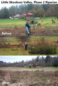
- Little Skookum Valley, Phase 2 Riparian – Implemented placement of 9 Large Woody Debris (LWD) structures, installation of riparian fencing, and installation of 1 acre of native riparian plants to improve stream habitat for salmonids (2003)
- Hiawatha Fish Passage Project – Replaced a failing, undersized, perched culvert with a fish-passable bridge 20-ft wide, 10’ft tall bottomless aluminum arch and re-graded downstream channel to mitigate erosion caused by high flows through the previous culvert, restoring access to 1.25 miles of stream habitat for thousands of salmonids; funded by SRFB and Mason County (2004)

- WRIA 14 Nearshore Project Development – Worked in partnership with the Squaxin Island Tribe to identify and design 6 nearshore restoration projects in WRIA 14 aimed to provide the greatest benefit to salmon, high likelihood of success, and landowner willingness (2004)

- Burns – Goat Hill Creek Passage Project – Replaced a barrier culvert (outfall drop, excessive water velocities, rusted out and failing) to install a large fish-passable arch culvert, providing access to 1.25 miles of stream habitat (2004)

- McDonald Land Company #1 Lynch Creek – Removed a partial fish passage barrier culvert and replaced it with a larger arch culvert to restore fish access to 1.5 miles of salmonid spawning and rearing habitat and allow downstream transport of large wood, streambed material, and high water flows (2004)

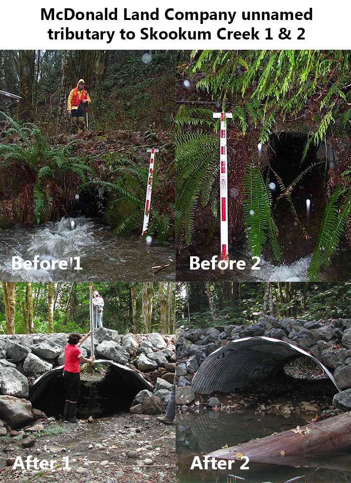
- McDonald Land Company unnamed tributary to Skookum Creek 1 & 2 – Replaced two fish passage barriers with adequately sized structures to restore salmon access to 1 mile of habitat while reducing the risk of road failure and damage to downstream habitat (2004)

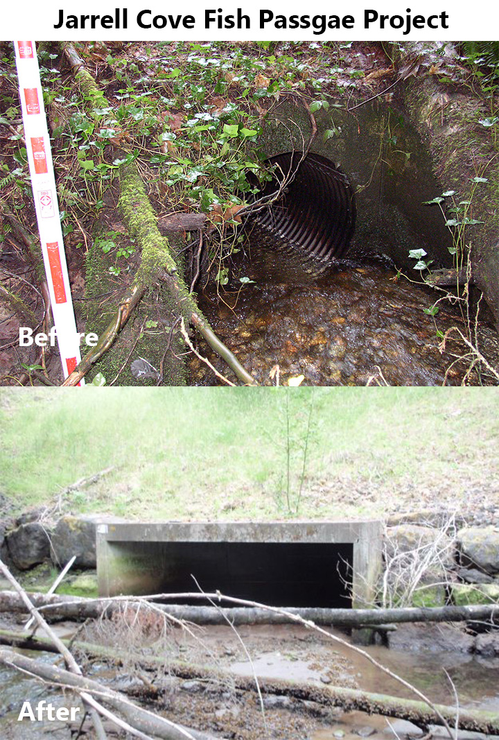
- Jarrell Cove Fish Passage Project – Replaced an undersized culvert in a tidal estuary that restricted stream function, tidal exchange, and salmon passage with a 14′ wide (122′ long) concrete box culvert, restoring ecosystem function and 2 miles of critical spawning habitat (2006)

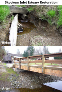
- Skookum Inlet Estuary Restoration – Removed several tons of concrete beach armoring and pilings along 1 mile of shoreline; an old timber stream crossing that blocked fish passage and limited tidal exchange was replaced with a 30’ timber bridge opening up 3 miles of stream habitat; added Large Woody Debris (LWD) structures; re-established native plants in a 2-acre wetland/salt marsh (2006)
- Sherwood Berm* – Removed a 60-year old berm (created to protect shellfish beds from the freshwater of Sherwood Creek), restoring much of the natural estuary; funding from NFWF and South Sound Fly Fishers (2006)
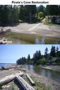
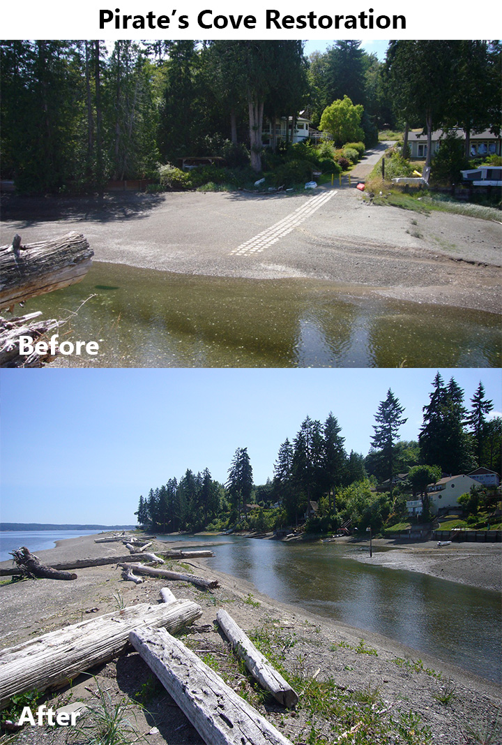
- Pirate’s Cove Restoration – Mitigated erosion and restored estuary hydrology with reversal of man-made modifications to a spit and lagoon; funded by SRFB and the Washington Department of Ecology (2007)
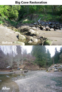
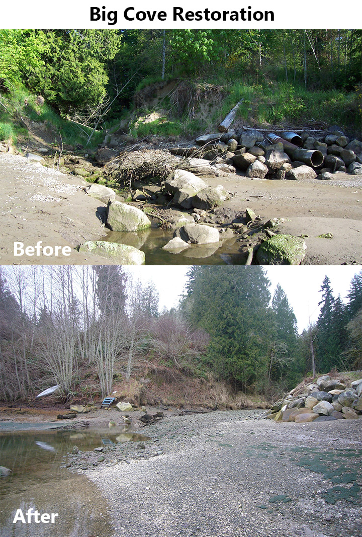
- Big Cove Restoration – Repaired ½ acre of nearshore estuary/freshwater fringe habitat and restored tidal connectivity to upstream freshwater habitat by removing shoreline armoring, removing a defunct/failed earthen tidal dam, removing an abandoned culvert, removing silty material and invasive reed canary grass, and planting native plants (2008)
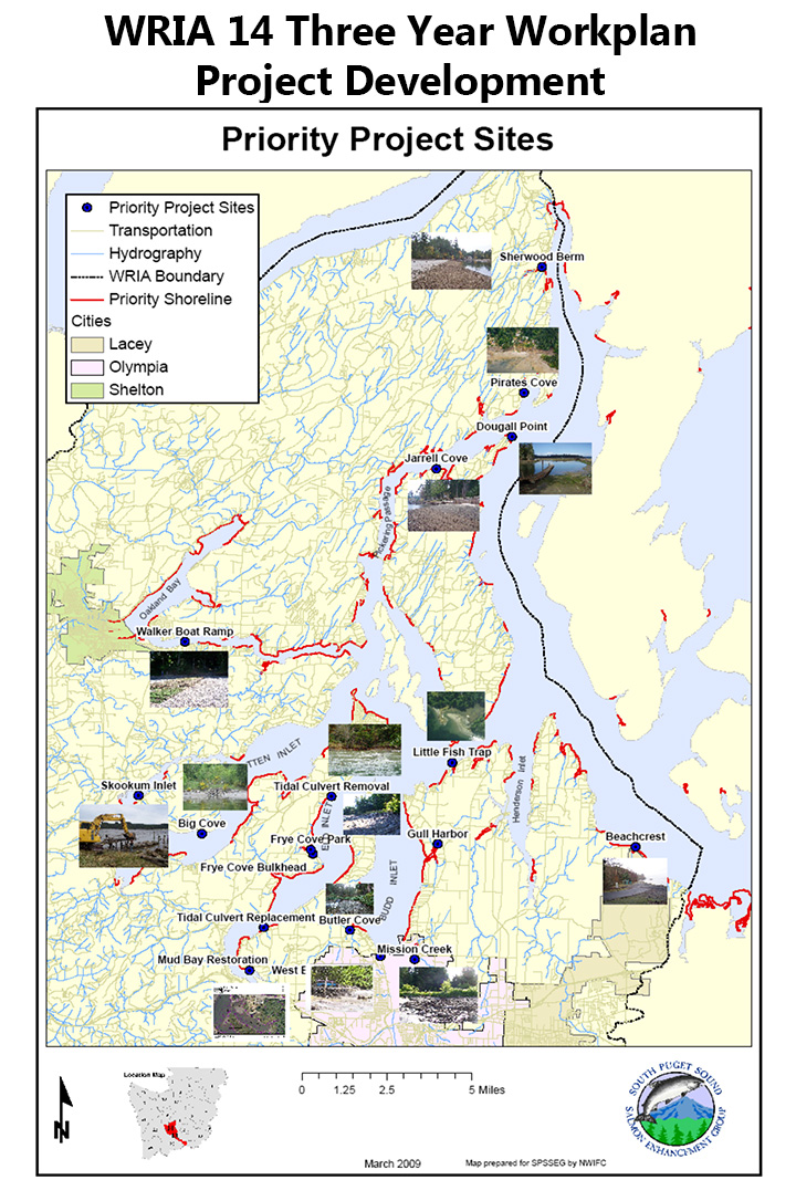
- WRIA 14 Three Year Workplan Project Development – Collaborated with stakeholders to develop 9 conceptual designs and 2 preliminary designs for salmon habitat projects in both marine and freshwater ecosystems (2010)

- Goldsborough Creek Planting* – Completed riparian planting adjacent to the former Goldsborough Dam on a barren slope to improve riparian habitat (2010)
- Sherwood Creek Monitoring* – Partnered with the Squaxin Island Tribe and Allyn Salmon Enhancement Group to monitor summer fish presence in the creek (2010)
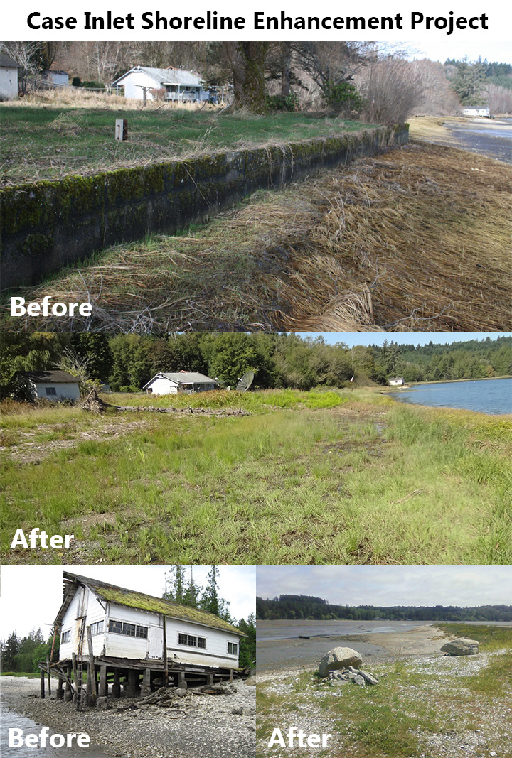
- Case Inlet Shoreline Enhancement Project – Removed derelict structures and bulkhead from abandoned shellfish processing facility located on the shoreline (2011)

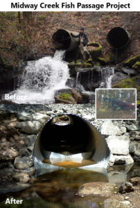
- Midway Creek Fish Passage Project – Replaced 2 side-by-side fish barrier culverts (perched 8’ above downstream creek) on a tributary to Goldsborough Creek with fish-passable culverts, gaining 0.6 miles of stream habitat (2011)
- Squaxin Island Pier and Bulkhead Removal – Worked with the Squaxin Island Tribe to complete engineering, design, and removal of an abandoned 210’x15’ creosote pier with 54 pilings and 350 feet of rock bulkhead, enhancing nearshore processes and removing toxic creosote from salmon habitat (2011)

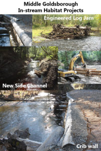
- Middle Goldsborough In-stream Habitat Projects – Placed in-stream Large Woody Debris structures (180’ long log crib wall and 4 engineered log jams) to stabilize the bank, create pool habitat for salmonids, and enhance stream morphology (2012)
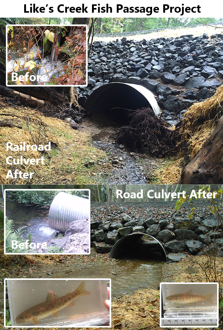
- Like’s Creek Fish Passage Project – Restored anadromous fish access to Like’s Creek, a major tributary to Goldsborough Creek by removing 2 separate sets of full barrier culverts and replacing them with larger fish passable culverts, removing 3 additional fish passage impediments at other road crossings, adding large wood to improve habitat complexity, thus opening up 1 mile of critical salmon habitat (2013)

- Collier Boat Ramp and Jetty – Worked in partnership with the Squaxin Island Tribe to remove two sediment barriers (a private boat ramp and a large boat basin) improving spawning habitat for forage fish (an important food source for Puget Sound salmonids) (2014)

- Arcadia Point Structure Removal Project* – Removed a private boat ramp and boat basin structure to improve natural beach processes like sediment transport/drift, thus improving spawning habitat for forage fish, which are important food for salmon (2014)
- West Oakland Bay Restoration and Conservation Phase 1 – First phase completed working in the Goldsborough Creek estuary in partnership with the Squaxin Island Tribe to rebuild lost salt marsh habitat, construct 14 engineered log jams at the mouth of the creek to capture sediment, create intertidal benches/shelves to accommodate natural vegetation, import bed material to create new salt marsh, remove shoreline armoring, thus benefiting multiple salmon and trout species during estuary residence; Multi-phase project goals: protect 51 acres of saltmarsh; conserve 14 acres of riparian habitat; restore and protect 0.8 miles of marine shoreline; restore 47 acres of estuary saltmarsh; remove ¼ mile of dikes and ½ mile of shoreline bulkheads; funding from National Coastal Wetlands, National Estuary Program, National Fish and Wildlife Federation, Salmon Recovery Funding Board, Simpson Timber, Port of Shelton, and Squaxin Island Tribe (2016)

- Panhandle 4-H Goldsborough Tributary Fish Passage Project – Restored fish passage to 2.26 miles of salmon habitat by replacing a failed culvert with high slope and outfall drop with a bridge over the stream crossing (2017)

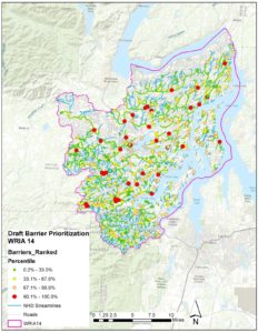
- Fish Passage Inventory WRIA 14 – Assessed 276 passage structures, identified 550 fish passage barriers, prioritized barriers, and produced preliminary designs for two priority sites (2018)
- West Oakland Bay Restoration Phases 2 and 3 – [in-progress] Completed the final phase of Oakland Bay Restoration project to restore 17 acres of saltmarsh habitat and remove ¼ mile of bulkhead, stabilize 4 acres at the mouth of Shelton Creek, and restore 1 acre of sill, all within the estuary of Goldsborough Creek (2021)
- Skookum Creek RM 6.5 Restoration – [in-progress] Improved main-stem, riparian, and off-channel stream and riparian habitat through invasive plant control, planting, and placement of large wood pieces along 400’ of Skookum Creek (2021)
- Kennedy Creek Floodplain and Estuary Functional Assessment* – (2022)
- Lightbody Riparian Restoration* – (2022)
- Fiscus Creek Foot Bridge Replacement* – (2023)
- Shadow Valley Fish Passage Design – [in-progress] Completed a preliminary design for a fish passage project to replace a wooden fish ladder structure with a fish-passable structure and a stream channel at a private road crossing opening up fish passage upstream habitat for the first time in decades (2023)
- Lingle Riparian Restoration* – (2023)
- Fiscus Creek Culvert Replacement Bridge Design* – (2023)
- Fiscus Creek Culvert Replacement* – [in-progress] Replaced a failing culvert on a prime chum salmon spawning stream with a fish-passable bridge (2024)


Projects in Thurston County have included:
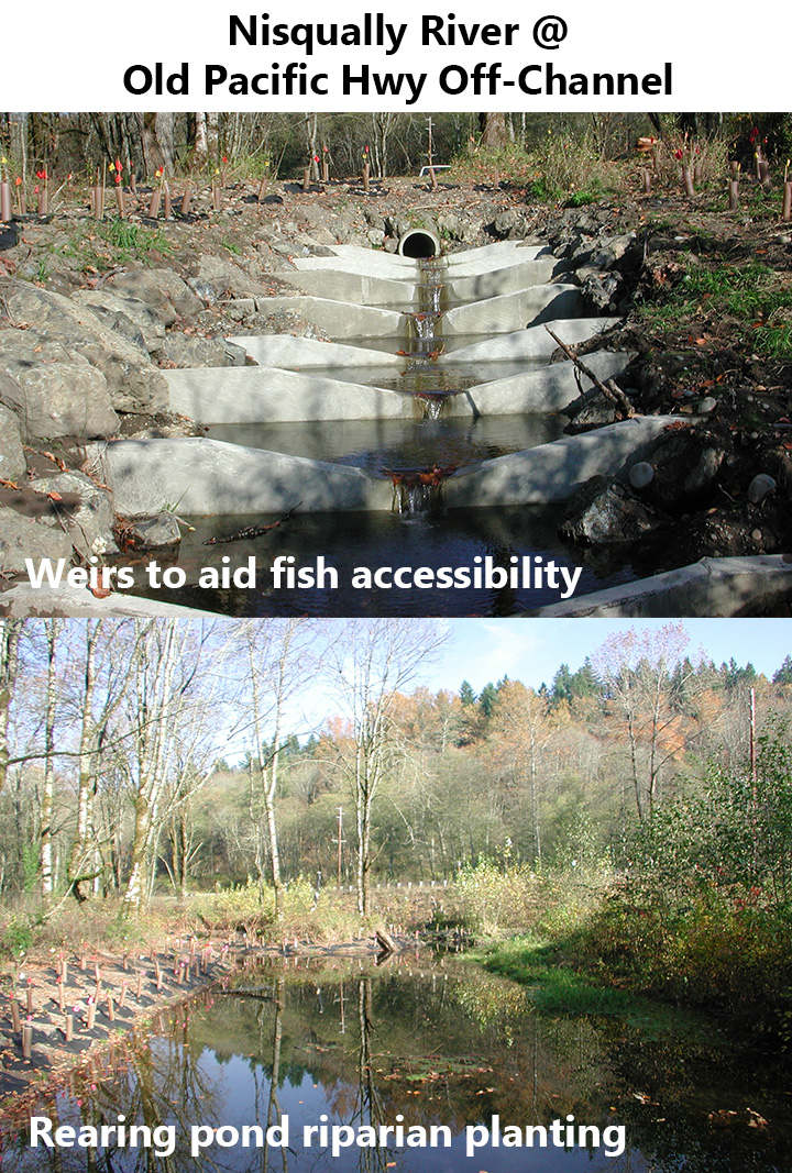
- Nisqually River @ Old Pacific Hwy Off-Channel – Enlarged and enhanced (added rootwads and logs for fish cover, planted native trees and shrubs for shade) an existing off-channel salmonid rearing pond, removed fish passage blockage and installed weirs to assist with fish access (2001)

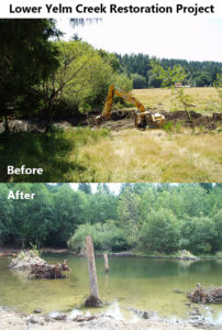
- Lower Yelm Creek Restoration Project – Reconstructed an historic off-channel pond, added wood for juvenile cover, excluded livestock from the creek with fencing, and notched a logjam to allow for fish passage, opening up and improving 10 miles of stream habitat for salmonids (2002)
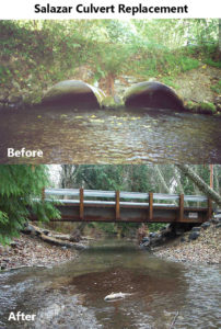
- Salazar Culvert Replacement – Replaced a set of earthquake-damaged, partial barrier culverts on Woodland Creek with a bridge to allow for fish passage for salmonids at all life stages and movement of streambed material (2002)
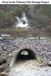
- Perry Creek Tributary Fish Passage Project – Replaced a pair of fish passage barrier culverts (perched 0.9m and 1.7m above the stream) with a bottomless fish passage structure, removed a man-made rock waterfall passage barrier, conducted in-stream channel work to mitigate streambed scour from the previous culverts, opening up 0.81 miles of stream habitat to salmonids (2002)
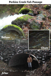
- Perkins Creek Fish Passage – Replaced a total anadromous barrier culvert (6% slope and undersized) with a larger structure to allow unimpeded salmonid migration at all life stages as well as passage of stream bed material and large woody debris, opening up 1.0 miles of high quality spawning and rearing habitat (2003)
- Eason-Frye Cove Creek Culvert – Replaced a severely damaged, fish-blocking culvert with a much larger culvert more suitable for the flows and debris load of the creek, opening up 1.25 miles of stream habitat for salmonids (2004)

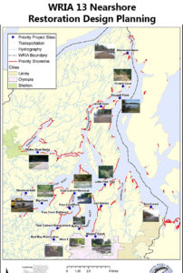
- WRIA 13 Nearshore Restoration Design Planning – Identified restoration opportunities along the shorelines of WRIA 13, focusing on projects to restore estuaries and nearshore processes (e.g. sediment and wood recruitment) (2004)
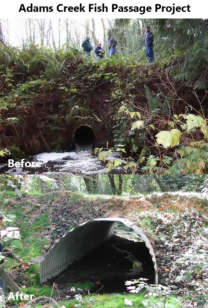
- Adams Creek Fish Passage Project – Removed a fish passage barrier (perched, undersized 2.5’ round culvert) and replaced with a 10’ round stream simulation culvert, opening up 1 mile of salmonid stream habitat (2004)

- Galivan – Perry Creek Trib Culvert – Removed two undersized barrier culverts and replaced them with a single, large, no slope, squash culvert suitable to pass high water flows, sediment bed-load material, LWD, and all life stages of salmonids access to 1.0 miles of stream habitat (2004)

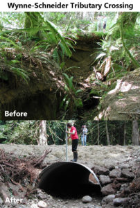
- Wynne-Schneider Tributary Crossing – Replaced a failing log crossing that blocked all fish passage on a significant salmon-bearing stream with a large culvert, opening up access to 0.7 miles of complex fish rearing habitat including beaver dams, ponds, and small tributaries (2005)
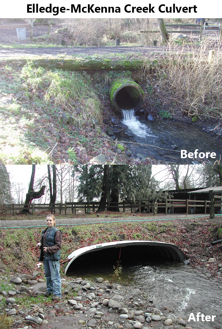
- Elledge-McKenna Creek Culvert – Removed an undersized (36”) and perched fish-blocking culvert and replaced it with a 112-inch diameter half-arch culvert, restoring access to 2 miles of critical off-channel over-wintering habitat for salmonids on a tributary of the Nisqually River (2006)

- Frye Cove Bulkhead Removal – Removed a 110’ long eco-block bulkhead that was encroaching onto the beach by 35’, restored the beach, and armored the bluff with boulders and LWD to protect the landowner’s home and open up 2.5 acres of potential forage fish spawning habitat (2006)

- Schneider LWD* – Placed 21 logs to improve salmon spawning and rearing habitat, removed several tons of in-stream concrete, placed 1,500 cuttings and plants in the riparian buffer along Schneider Creek; funding from NFWF (2006)
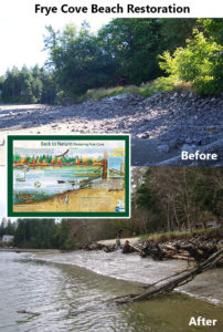
- Frye Cove Beach Restoration – Removed 1,000 cubic yards of rip-rap armoring along 450 feet of shoreline and installed beach-profile LWD, restoring natural beach processes and improving 2.1 acres of beach for forage fish and salmonid habitat (2007)
- Spurgeon Creek Culvert Removal* – Removed a defunct culvert; $3,000 funding from NFWF and Thurston County (2007)
- Powell Creek Project* – Removed 3 fish barrier culverts and one overflow culvert, a defunct bridge abutment and associated rip-rap adjacent to the Nisqually River, and decommission 2,900 feet of private road to provide fish passage to Powell Creek for spawning salmonids and increase hydrologic connectivity from the Powell Creek wetland complex to the Nisqually River; funded by the Pacific Salmon Commission, USFWS, and SRFB (2008)
- Powell Creek Fish Passage Project* – Replaced a crushed culvert with a 50-ft bridge to reconnect fish access to a wetland complex and high quality salmon spawning habitat; funded by FFFPP (2008)
- Galivan – Perry Creek Tributary Storm Repair – Repaired storm damage to completed FFFPP project due to extremely high flows and mobilization of debris (2008)

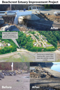
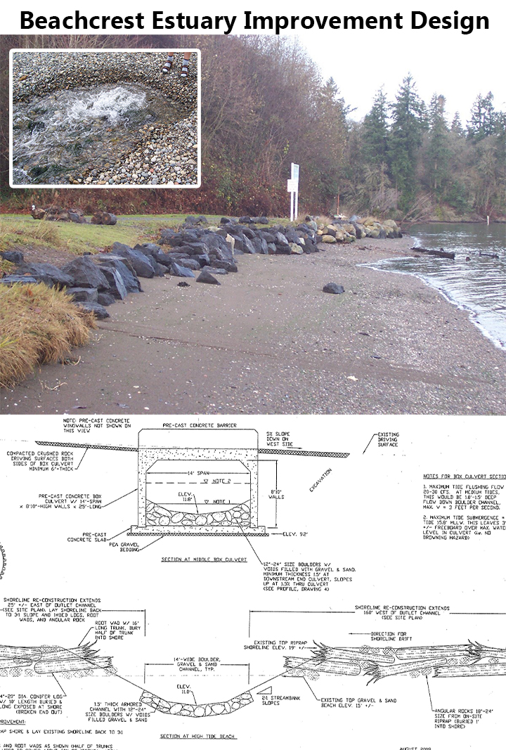
- Beachcrest Estuary Improvement Design – Completed 100% design and permits for a fish passage solution and riprap bulkhead removal in a tidal channel in order to restore access for salmonids to 1.5 acres of stream and estuary habitat (2008)
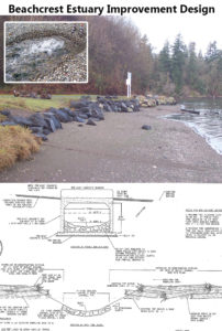
- Beachcrest Estuary Improvement Project – Restored salmonid access (after 65 years of impoundment) to and habitat within a pocket estuary along the Nisqually Reach by removing riprap bulkhead, adding a 14’ wide box culvert, adding LWD, and creating a semi-natural stream channel to connect the salt- to fresh-water fringe habitat (2009)
- Chaffee-Lackamas Creek Fish Passage – Replaced an undersized culvert that flooded/partially washed out the road with fish-passable bridge, gaining 2.4 miles of stream habitat for salmonids (2009)

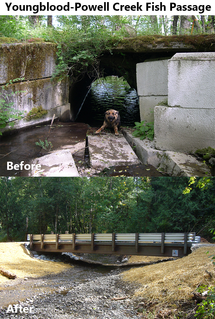
- Youngblood-Powell Creek Fish Passage – Replaced an undersized culvert that regularly flooded with a fish-passable 50’ steel bridge, added three grade control log jams, installed 200 native plants in the riparian zone, gaining 6.8 miles of stream habitat for salmonids (2009)

- Woodland Creek Restoration* – Partnered with St. Martin’s University to restore a small reach in Woodland Creek by fixing a partial fish barrier using a roughened channel approach and removing a small timber bridge to improve fish passage and sediment movement (2009)
- Eld Inlet Culvert Removal* – Removed a barrier tidal culvert at the mouth of a small estuary; funded with NFWF (2009)
- WRIA 13 Three Year Workplan Development – Prioritized, selected, and designed 10 conceptual projects with multi-species salmon focus in marine and freshwater ecosystems (2010)

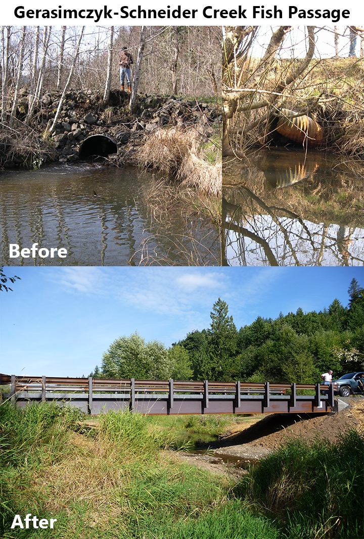
- Gerasimczyk-Schneider Creek Fish Passage – Replaced a pair of barrier culverts on an eroding road with a fish-passable bridge, opening up 4.5 miles of high quality stream habitat with access to beaver ponds and wetlands (2011)

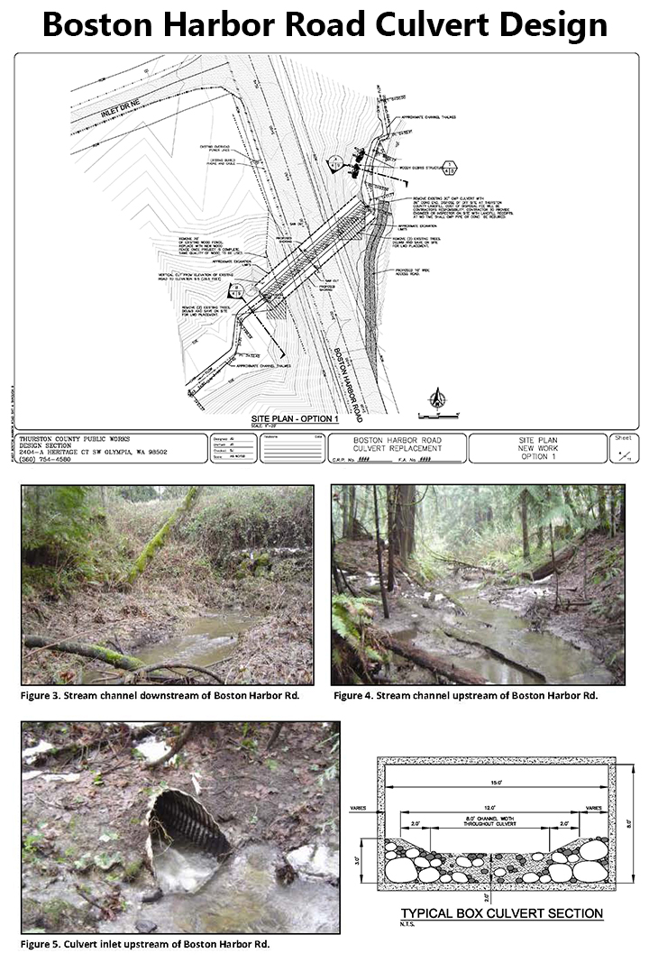
- Boston Harbor Road Culvert Design – Completed a preliminary design to replace a culvert impassable to fish due to being undersized, having a high slope, and an inlet drop (2011)

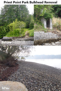
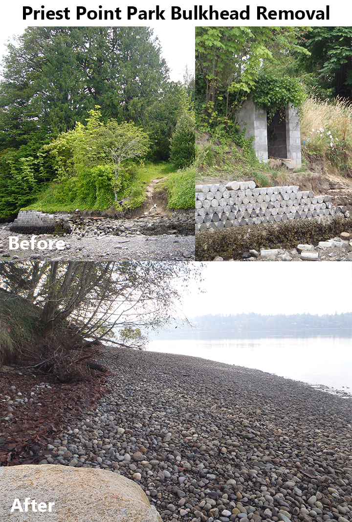
- Priest Point Park Bulkhead Removal – Removed 150 of concrete bulkhead, adding LWD and removed invasive vegetation on bluff and replaced with native plant species, restoring 0.8 acres of shoreline and estuary (2011)
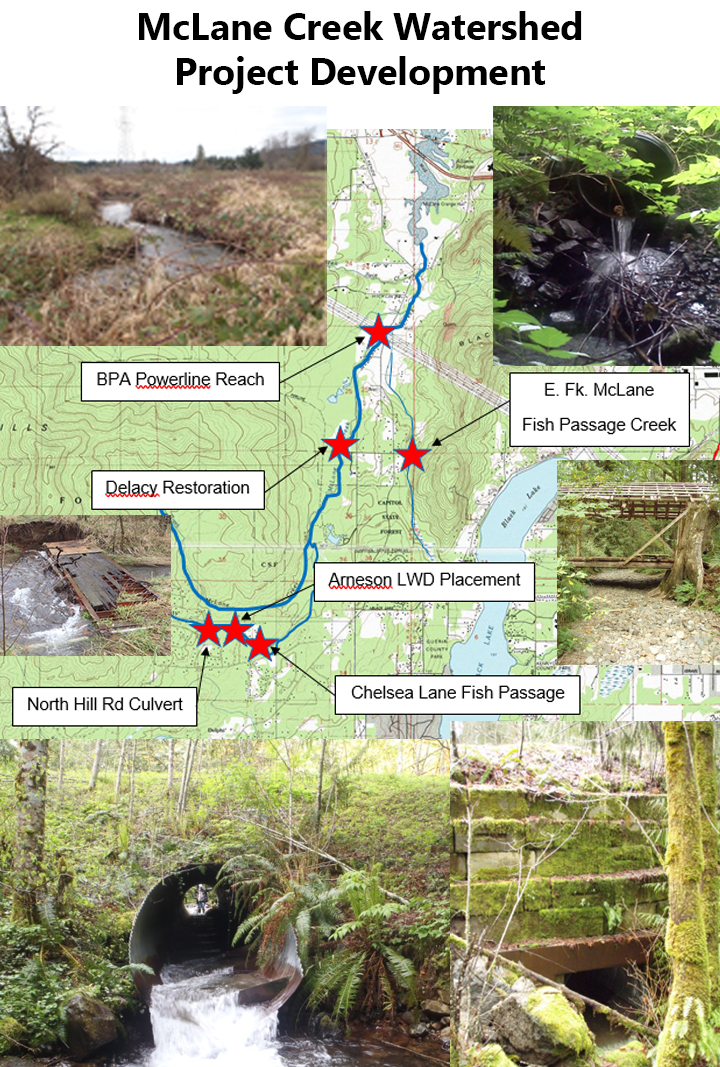
- McLane Creek Watershed Project Development – Completed preliminary designs for 5 restoration projects in the McLane Creek watershed, assessed the extent of Japanese Knotweed riparian invasion, conducted landowner outreach (2011)

- Deschutes River ELJ/LWD Design – Completed full designs for LWD placement on the mainstem Deschutes River at RM 21 (2011)

- Allison Springs Shoreline Enhancement* – Restored shoreline habitat and completed vegetation planting in partnership by Capitol Land Trust (2011)
- PERS SRV Barrier Evaluation – Completed evaluation of barriers to fish passage, providing field data on projects that have been enrolled in the Family Forest Fish Passage Program (2012)
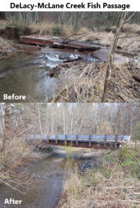
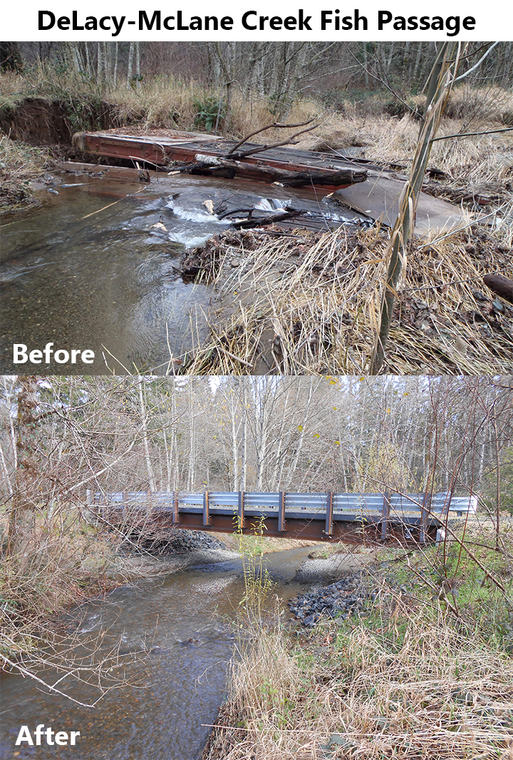
- DeLacy-McLane Creek Fish Passage – Replaced a collapsed bridge that was blocking water and fish passage with a new bridge, improving access to 8.51 miles of excellent salmonid habitat (2012)
- McLane Creek LWD Placement and Riparian Restoration – Restored and enhanced degraded stream channel that was widened and experienced interrupted sediment and water flow due to impacts from an old rail car bridge that had collapsed and fallen into the water, placed large wood structures in the stream to form pools and sort sediment, planted ¼ acre with native plants, improving 0.7 acres of habitat for salmonids (2013)

- Little Fish Trap Beach Restoration Design – Completed a final design to restore a small pocket estuary, remove a barrier spit adjacent to a freshwater salmon stream, and allow for natural ecosystem processes (2013)

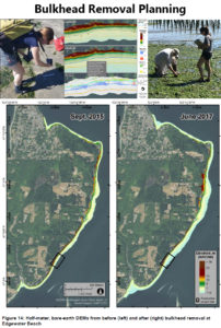
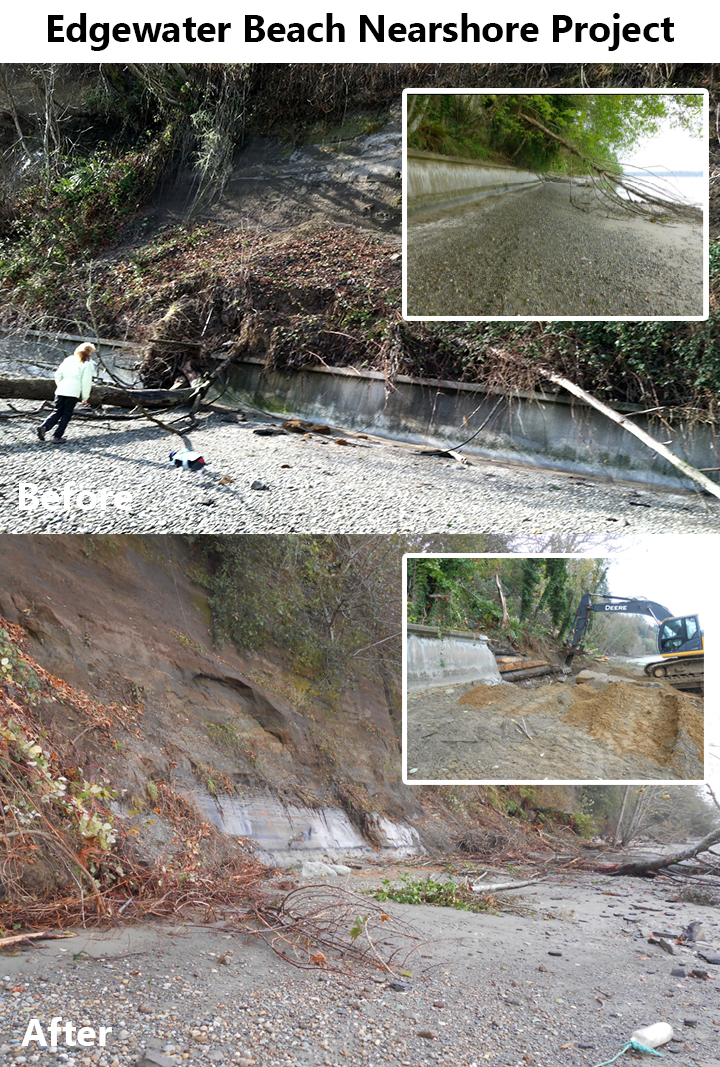
- Edgewater Beach Nearshore Project – Removed a bulkhead and 800 feet of armoring to restore nearshore processes (e.g. sediment input, erosion, creation of inter-tidal habitat) to benefit salmonids and forage fish (2014)

- Frank’s Tidelands Design Only – Completed a preliminary design and assessment for restoration and enhancement to shoreline to benefit salmonids, forage fish, and shellfish by removing creosote structures, re-contouring the shoreline, and adding new sediment (2014)

- Pioneer Park Restoration Preliminary Designs – Developed a preliminary restoration design at Pioneer Park along the Deschutes River to restore aquatic habitat by increasing large woody debris, re-establishing native riparian forest, and creating in-stream complexity while maintaining public usability during summer low-flows (2015)

- Bulkhead Removal Planning – Monitored changes in ecological and geomorphological parameters following the Edgewater Beach nearshore bulkhead/armoring removal and beach restoration project (2015)
- Lower McLane LWD – Installed 3 engineered log jams (ELJ) on four private properties within the upper limits of tidal exchange to improve 0.5 miles of stream habitat (e.g. create large complex pools, sort gravel, and allow stream flow through jams) that is heavily used by several species of spawning and rearing salmonids (2015)

- Deschutes RM 21 LWD & Riparian Design – Completed preliminary design for a 1500-ft reach of the Deschutes River to enhance salmon habitat by adding large woody debris, channel complexity, and bank roughness to a degraded area, and plant and maintain a riparian buffer of native plants, with the goal of reducing fine sediment erosion, create thermal refuge pools, and add large woody materials to benefit salmonids (2016)

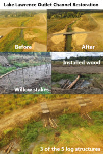
- Lake Lawrence Outlet Channel Restoration – Removed a partial fish passage barrier culvert wand replaced with a full spanning bridge, increased stream habitat by installing complex log jams, planted 3 acres with native trees and shrubs (2016)
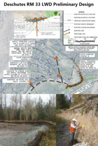
- Deschutes RM 33 LWD Preliminary Design – Developed preliminary designs to add large woody debris, reduce fine sediment input to the stream, create pools for refuge, and increase habitat quality along 1,500 linear feet of salmon habitat (2016)
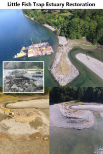
- Little Fish Trap Estuary Restoration – Removed 0.13 miles of shoreline armoring, restoring nearshore processes and sediment movement on the beach and opening up 450′ of forage fish spawning habitat and increasing salmonid access to a pocket estuary for food and rest opportunities (2017)
- Butler Cove Estuary Connectivity Project – Removed a series of abandoned fish rearing ponds, developed conceptual designs to replace a fish passage blocking culvert upstream, and restored estuary ecosystem processes salmonid habitat (2017)

- Spurgeon Creek Restoration – Enhanced riparian restoration on 5-acres installing 1,660 native plants (originally planned as a steam re-meandering project but found to be unfeasible due to soils) (2017)

- Lower McLane Creek Restoration Project* – With the help of volunteers, installed 1,211 riparian plants to increase stream-side shading and 8,400 willow stakes to treat reed canary grass in the floodplain; funded by Thurston Conservation District and Olympia Trout Unlimited (2017)
- Beatty Creek at Chelsie Lane Fish Barrier Replacement – [in-progress] Replaced a failed fish barrier culvert with a bridge (or-over-sized culvert) to restore stream processes and and salmonid access to 1.9 miles of stream habitat (2019)
- LWD & Riparian Planting at Deschutes RM 21 – [in-progress] Improved instream complexity, increased cold water salmon refuge habitat, increased off-channel connectivity for high-flow refuge, and reduced harmful fine sediment input by installing 8 large wood habitat complexity structures, adding 1 ELJ, planting a 100’ riparian buffer covering 12 acres, and creating 2 pools (2019)
- Deschutes RM 34.5 In-stream Complexity – [in-progress] Mitigated limiting factors to salmon survival by adding stable large woody debris for pool and gravel formation, decreased summer channel width to increase water depth, added riparian vegetation to reduce sediment input and increase stream shading, thus improving 1,500 linear feet of river channel (2020)
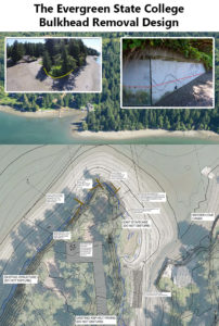
- The Evergreen State College Bulkhead Removal Design – Completed engineering design to remove of 215’ of bulkhead to restore natural shoreline habitat, forage fish spawning grounds, and sediment processes to benefit salmon, orca, and birds (2021)
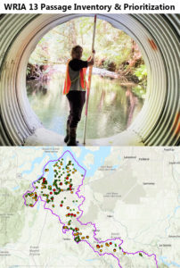
- WRIA 13 Passage Inventory & Prioritization – Assessed 174 fish passage barriers (mainly culverts), and produced a complete and prioritized inventory of fish passage barriers in WRIA 13, many of which were never assessed or had unknown current statuses (2021)
- Evergreen Bulkhead Project – [in-progress] Restored 500-feet of nearshore habitat by removing a 220’ concrete bulkhead and stairway and planting 0.8 acres of riparian habitat behind the structure, removing the final piece of the longest un-armored section of shoreline on Eld Inlet, restoring sediment transport and improving juvenile salmonid habitat (2022)
- Upper Deschutes Conceptual Design – [in-progress] Building on recently completed scientific reports/assessments, completed a conceptual design restoration treatment to address limiting factors for salmonid survival (2022)
- Griggs Creek Griffinwood Fish Passage – [in-progress] Replaced a total blocking culvert with a fish-passable structure at a private road crossing, opening up fish passage to Griggs Creek for the first time in decades (2023)


Projects in Pierce County have included:
- 96th Street Oxbow Project – Reconnected a historic oxbow within the Puyallup River floodplain by removing a 12” culvert set high in the levee and replacing it with a 6’ diameter culvert set at a low flow elevation, providing fish access to the 4-acre oxbow and 23-acre wetland, removed invasive plants to improve salmonid access (2000)

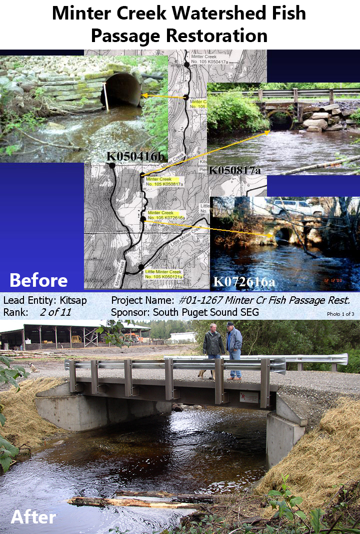
- Minter Creek Watershed Fish Passage Restoration – Completed 3 fish passage projects in the Minter Creek watershed, opening up 8.1 miles of stream habitat by replacing barrier culverts with fish passable structures (bridges and larger culverts) (2002)

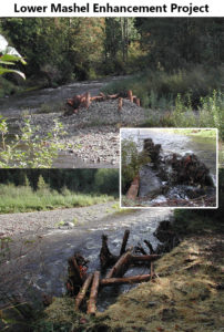
- Lower Mashel Enhancement Project – Modified 1,500 feet of a previous washed-out road to stop fine sediment input; enhanced salmon habitat by adding 7 large woody debris (LWD) jams to create pools, sort gravel, increase cover, and reduce bank erosion; stabilized 1.4 miles of streambank; 0.7 acres planted with native riparian vegetation (2002)
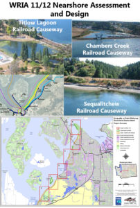
- WRIA 11/12 Nearshore Assessment and Design – Assessed nearshore habitat between the Nisqually River and Point Defiance to identify and prioritize potential restoration projects likely to benefit salmon, completed preliminary engineering designs for estuarine restoration at 3 specific project sites (2004)
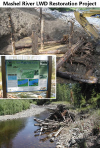
- Mashel River LWD Restoration Project – Installed 13 engineered log jams to improve spawning and rearing habitat for salmonids (2004)
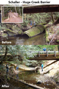
- Schaller – Huge Creek Barrier – Removed a partial barrier culvert on a salmon-bearing tributary to Minter Creek and replaced it with a full-spanning steel bridge, improving access to 14.66 miles of salmonid spawning and rearing habitat (2005)
- Robinson-WF Rocky Creek Barrier – Replaced a barrier culvert (partially crushed and rusted, undersized, steep slope, outfall drop, high velocity) with a fish-passable 10’ diameter culvert, making 3.47 miles of stream habitat accessible to salmonids (2005)

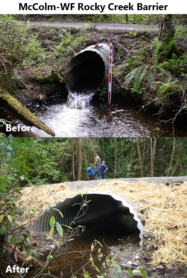
- McColm-WF Rocky Creek Barrier – Replaced a rusted, undersized, perched culvert with a 14’ wide bottomless fish-passable culvert, making 3.45 miles of stream habitat accessible to salmonids (2005)

- Rocky Creek Barrier Replacement – Replaced an undersized barrier culvert that regularly flooded the road and impeded salmon migration with a large box culvert, opening up 5 miles of stream habitat for salmon and mitigating flood impacts for landowners (2006)

- Silver Creek Barrier Removal* – Modified two derelict fish hatchery diversion dams to allow unimpeded fish passage; $9,000 funded by USFWS (2006)
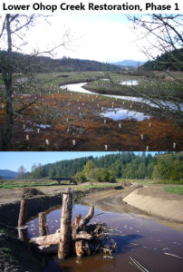
- Lower Ohop Creek Restoration, Phase 1 – Excavated 1 mile of stream channel to historical elevation and sinuosity, revegetated floodplain, installed 40+ log jams, installed streambed gravel, excavated 0.2 miles of side channel, eradicated 1 acre of reed canary grass (2006)
- Horn Creek Riparian Planting* – Installed 2,600 bare root and potted plants with volunteers and school groups to restore and enhance the riparian buffer and wetlands (about 3.5 acres) to benefit salmon and wildlife; funding from USFWS (2006)
- Shera’s Falls Fish Passage Project* – Added 150 cubic yards of alluvial sand, gravel, and boulders to the stream bed to alleviate a barrier falls near the mouth of Clover Creek in Lakewood; $30,000 funded by NFWF’s Pierce County Community Salmon Fund (2007)
- Clover Creek Improvements at Parkland Prairie Project* – Removed 600 linear feet of asphalt channel on Clover Creek and recreated a meandering stream profile to improve habitat complexity, riparian cover, and spawning and rearing capacity of Clover Creek; funded by NFWF and Pierce County Surface Water Management (2007)
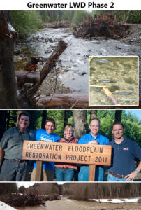
- Greenwater River ELJs and Road Decommission – Installed 5 engineered log jams, creating 5 in-stream pools to provide complex habitat with overhead cover for salmonids; connected 65 acres of historic off-channel habitat, removed ¾ of a mile of road from the floodplain (2007)

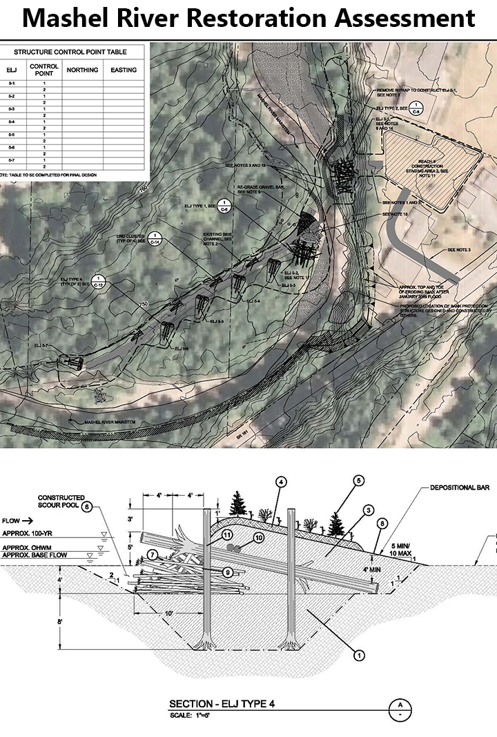
- Mashel River Restoration Assessment – Completed a habitat assessment to inform engineering design and cost estimates for restoration projects to benefit multiple life stages of salmonids (2007)

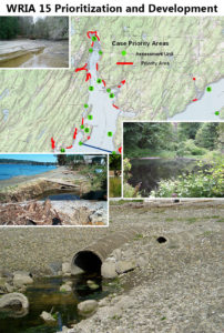
- WRIA 15 Prioritization and Development – Assessed and prioritized restoration opportunities (65 were identified) throughout the nearshore environment of the Key Peninsula-Gig Harbor-Islands watershed (2007)
- Nisqually Pines Project* – Replaced a 12” diameter culvert with a concrete footbridge over Walden Creek, allowing off-channel access to juvenile salmonids; funded by NFWF and South Sound Flyfishers (2007)
- Greenwater LWD Phase 2 – Installed 8 additional mid-channel engineered log jams, removed the remaining ¼ mile section of road from the floodplain (2008)
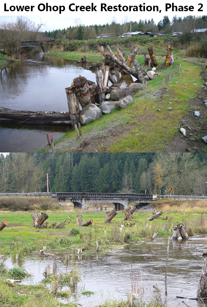
- Lower Ohop Creek Restoration, Phase 2 – Created 1.08 miles of new meandering channel to replace an incised ditch, reconnecting the creek with its historical 100-acre floodplain to benefit salmonids; revegetated 80 acres of floodplain with native species (2008)

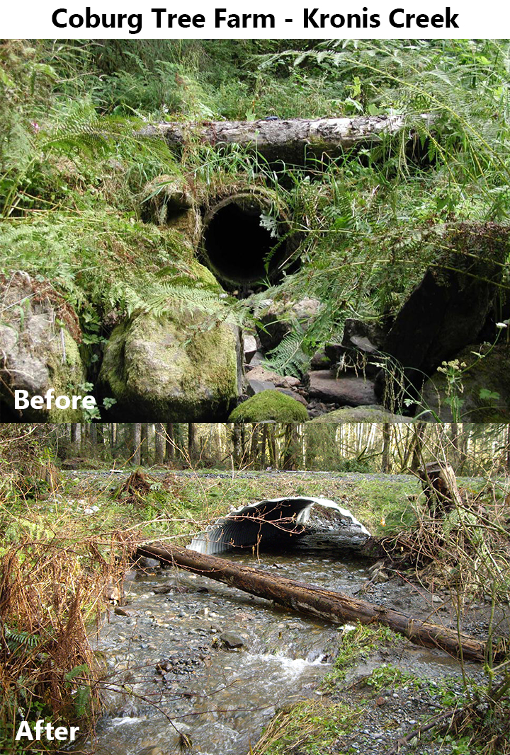
- Coburg Tree Farm – Kronis Creek – Replaced a 33% passable 24” culvert with a 12’ box culvert to allow unimpeded fish passage for all life stages of resident salmonids and improve woody debris passage, opening 0.62 miles of steam habitat (2008)

- Lackamas Creek Fish Passage Project* – Replaced 2 failing culverts with a 40-ft bridge and restored habitat in the Nisqually River tributary of Lackamus Creek; funded by FFFPP (2008)
- Clearwater River LWD Project – Strategically placed 18 large wood structures to increase spawning and rearing capacity of the watershed for salmonids along 0.8 miles of stream channel (2010)

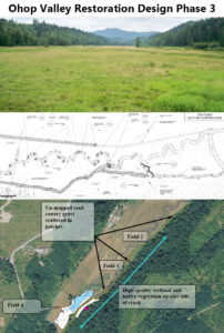
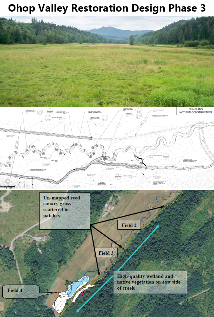
- Ohop Valley Restoration Design Phase 3 – Developed preliminary project designs to create a contiguous functional floodplain ecosystem between the confluence of Ohop Creek with the Nisqually River and Peterson Road (RM3) (2010)
- Mashel River Effectiveness Monitoring* – Monitored the success of restoration projects in the Mashel River to assist in development of a Nisqually Basin Chinook Recovery Monitoring Plan; funded by the Nisqually Indian Tribe (2010)
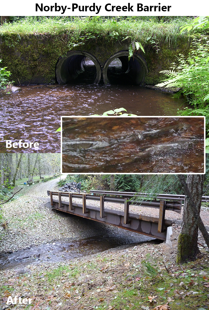
- Norby-Purdy Creek Barrier – Replaced a fish barrier set of undersized culverts on Purdy Creek with a 40’ steel bridge, improving salmonid access to 5.6 miles of excellent stream habitat (2011)

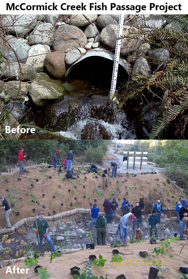
- McCormick Creek Fish Passage Project – Removed a 4’ barrier culvert and road fill on McCormick Creek allowing natural stream span and unimpeded fish migration for all life stages to 1.5 miles of stream habitat including wetland complex; removed invasive Himalayan Blackberry from stream channel and replanted disturbed riparian areas with 550 native trees and shrubs (2011)

- Penrose Point Bulkhead Removal-Final Design – Completed final designs to remove a creosote bulkhead and restore nearshore habitat and processes (2011)

- Penrose Point Bulkhead Removal-Construction – Removed a creosote bulkhead, rip rap armor, ad fill along a bluff backed beach in Penrose Point State Park, restoring sediment transport processes and improving the beach profile for rearing and foraging salmonids (2012)

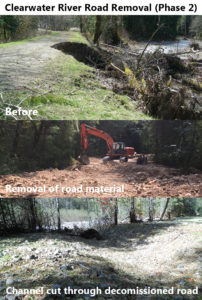
- Clearwater River Road Removal (Phase 2) – Removed 0.9 miles of road and 9,925 cubic yards of material to reconnect 14.25 acres of existing floodplain, including a wetland channel; removed 4 culvert crossings and installed 10 channels through the roadway to accelerate floodplain reconnection (2012)
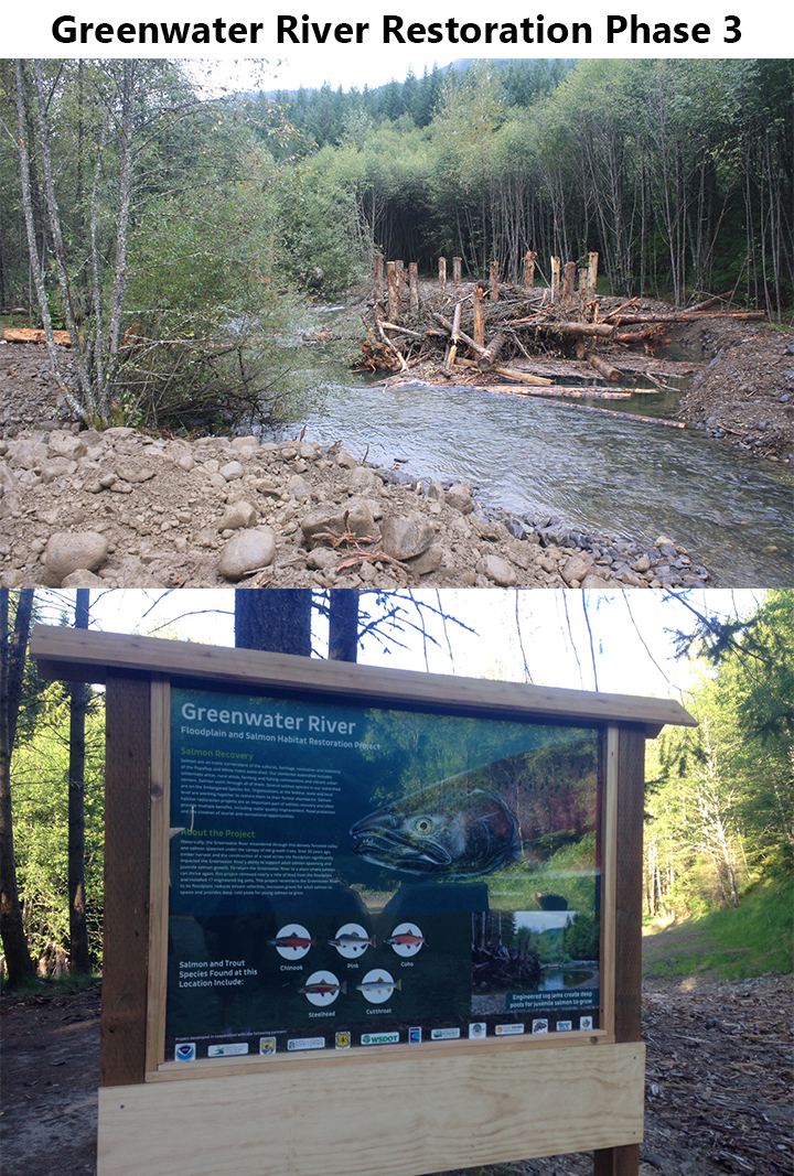
- Greenwater River Restoration Phase 3 – Installed 4 additional engineered log jams in a 0.5 mile reach of stream downstream of phase 1 and 2 project sites (2013)

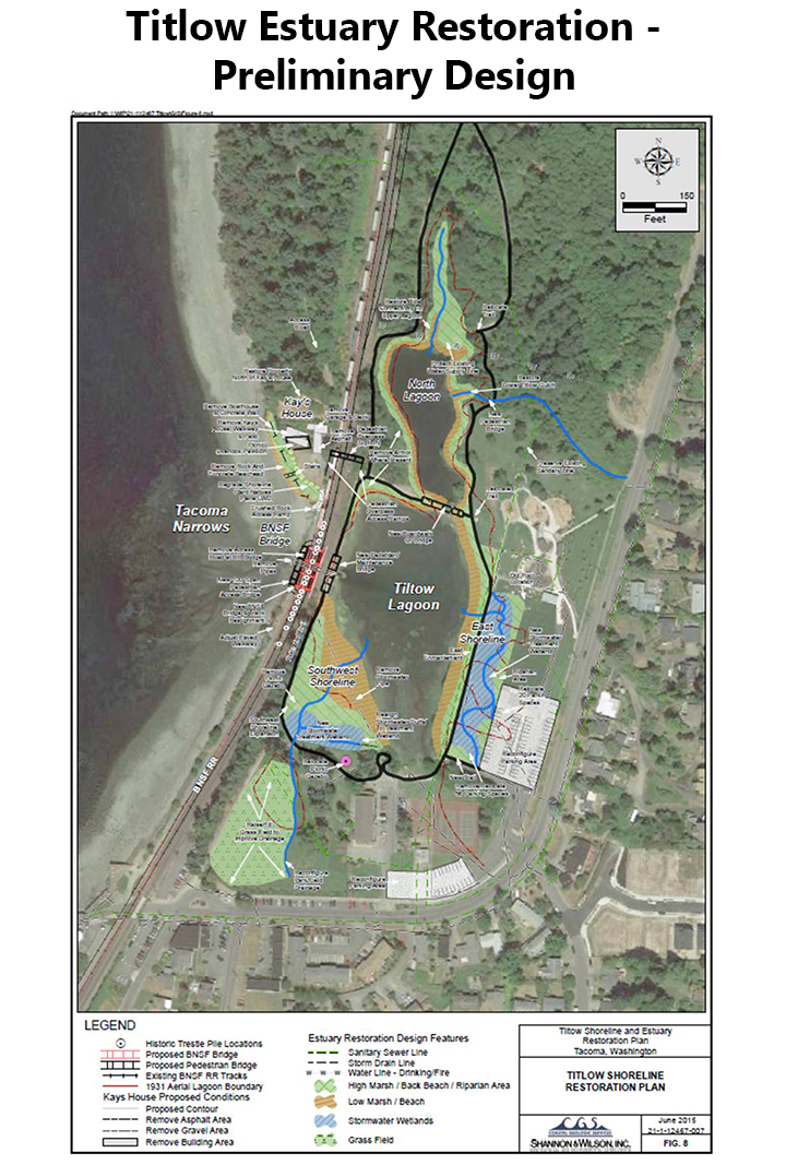
- Titlow Estuary Restoration-Design Development ESRP – Developed conceptual design plans to restore natural estuarine processes at Titlow Lagoon (2013)

- Filucy Bay Bulkhead Removal – Removed a portion of a vertical pile bulkhead and associated fill from shoreline in Carr Inlet to restore saltmarsh and food web productivity and enhance the beach for forage fish spawning and juvenile salmonid rearing (2013)

- Lower Ohop Creek Restoration, Phase 3 – Re-aligned 1.4 miles of creek, placed several LWD habitat structures, planted 20 acres with native riparian plants (2014)

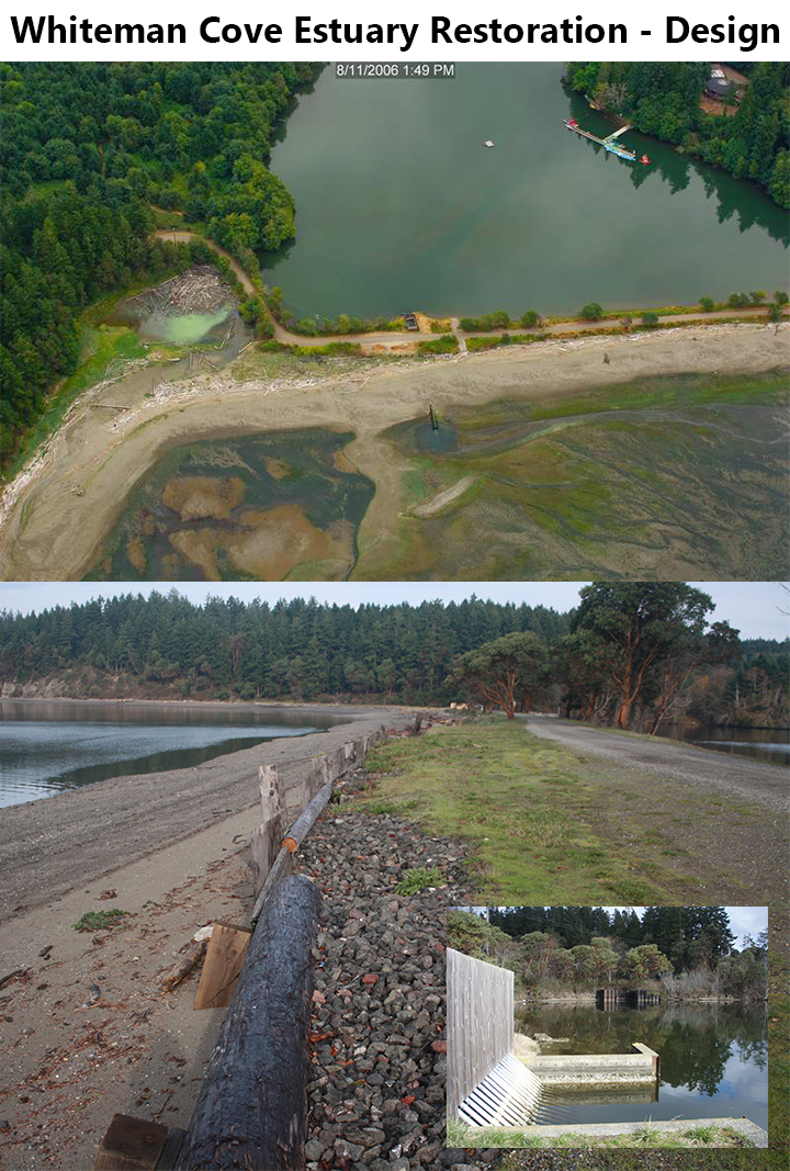
- Whiteman Cove Estuary Restoration – Design – Completed a data-driven analysis of the site that can be utilized by stakeholders in future project negotiations; possible actions identified could provide salmonid access to a 29-acre pocket estuary with 1.5 miles of shoreline and 1 mile of freshwater spawning and rearing habitat (2014)

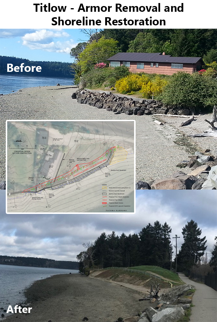
- Titlow – Armor Removal and Shoreline Restoration – Removed a derelict house, bulkhead/seawall, rip-rap armor, and contaminated soil from the shoreline to improve beach structure and sediment transport function on the shoreline north of the Titlow Lagoon (2015)

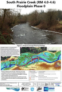
- South Prairie Creek (RM 4.0-4.6) Floodplain Phase 0 – Completed pre-final design plans and construction specifications for the South Prairie Creek Floodplain Restoration Project (2015)
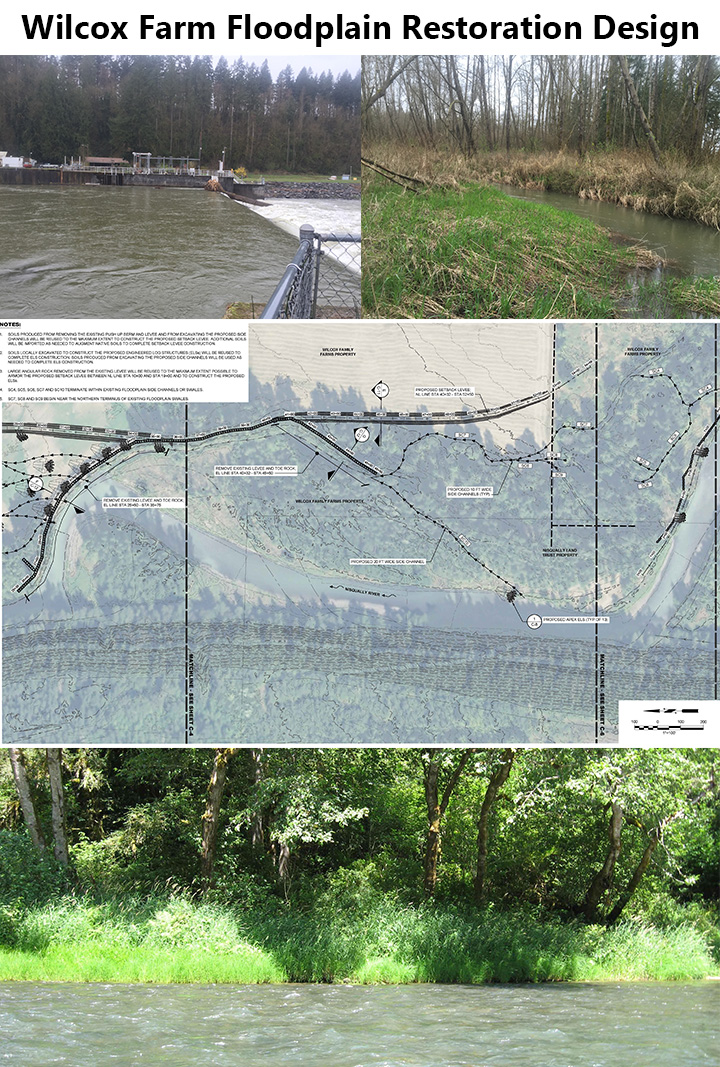
- Wilcox Farm Floodplain Restoration Design – Assessed the feasibility of property acquisition or conservation easements of key floodplain property; assessed the feasibility of partial or total removal of a levee on the mainstem Nisqually River; completed a conceptual design to allow for continued agricultural uses, protection of large portions of land in the floodplain, protection of the diversion dam, and armor/levee removal, and restoration of floodplain, wetland, and off-channel habitat for salmonids (2015)

- Clear Creek Floodplain Restoration Project* – [in-progress] In partnership with 22 organizations, SPSSEG served as the lead organization coordinating fish and habitat interests for Pierce County’s Floodplains for the Future program to implement a large body of work aimed at charting the course for future fish habitat restoration in the tidally influenced marsh lands of the Clear Creek watershed on the floodplain bench of the lower Puyallup River (2016)
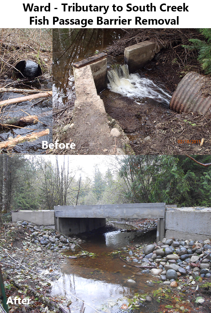
- Ward – Tributary to South Creek Fish Passage Barrier Removal – Removed 2 barrier culverts (excessive slopes) and replaced one with a fish-passable 14-foot wide concrete box culvert and abandoned the second crossing, restoring salmonid access to 1.5 miles of stream habitat (2016)

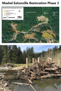
- Mashel Eatonville Restoration Phase 3 – Constructed 9 large woody debris (LWD) elements (engineered log jams) to increase spawning gravel and pools for salmonids; removed bank armoring and added bank roughness to improve floodplain engagement and minimize erosion; re-connected 2 side channels to increase high flow refugia for fish; and planted 5 acres of riparian vegetation to increase shade and woody debris inputs (2016)
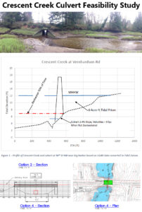
- Crescent Creek Culvert Feasibility Study – Completed a feasibility study to replace an undersized culvert on Crescent Creek that restricts tidal flow, partially inhibits fish passage, and fragments the estuary (2016)
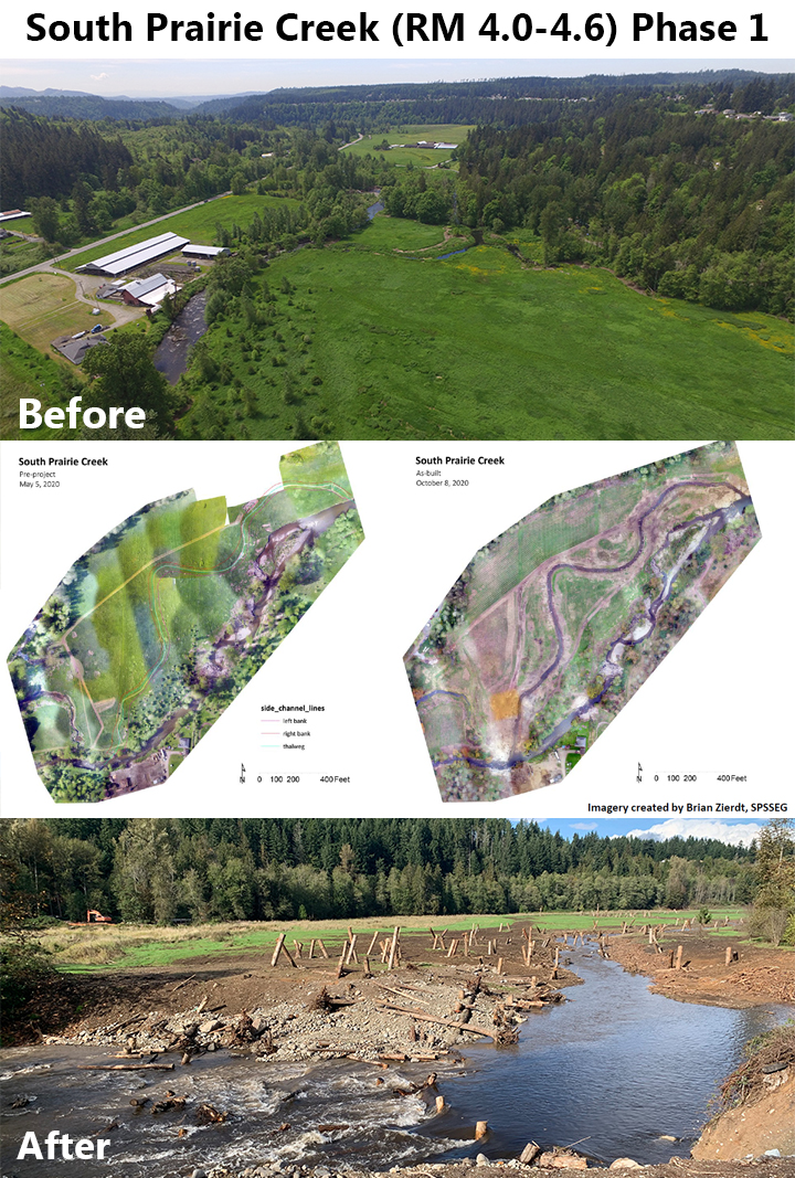
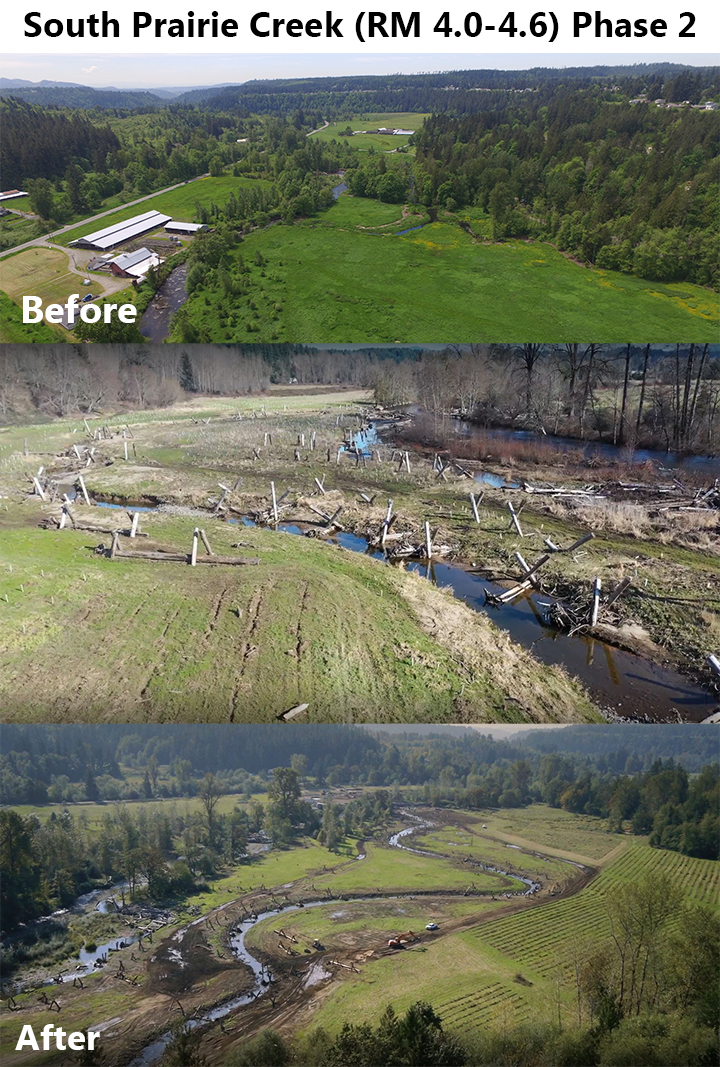
- South Prairie Creek (RM 4.0-4.6) Phase 1 – Implemented Phase 1 of stream and floodplain restoration to improve instream habitat, off-channel habitat, riparian function, and floodplain connectivity to increase salmon rearing capacity of system; Placed 3 channel-spanning and 12 mid-channel wood structures, installed 15 floodplain wood roughness structures, demolished an 80’ creosote bridge crossing on the main channel of South Prairie Creek and installed a 36’ steel bridge crossing over Silver Springs, demolished 9 remnant dairy buildings, planted 18 acres (2016)

- South Prairie Creek (RM 4.0-4.6) Phase 2 – In partnership with Pierce Conservation District, implemented Phase 2 of stream and floodplain restoration to benefit salmonids; Excavated and connected 2,600 linear feet (and 80 acres) of side channel habitat to provide year-round fish access, installed 91 engineered log jams for large stable wood accumulations, installed 5,600 cubic yards of slash in side channel banks/bed for roughness and edge habitat complexity, installed new plants and maintained previous revegetation on 45 acres (2017)

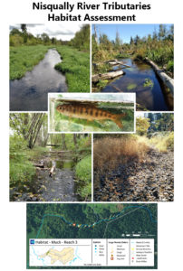
- Nisqually River Tributaries Habitat Assessment – Completed a salmon and steelhead habitat assessment for the Muck Creek basin, a major tributary to the Nisqually River; completed a preliminary design for a high priority passage barrier (2017)
- Little Mashel River Confluence Restoration Project* – In partnership with Nisqually Land Trust and the town of Eatonville, added 9 large wood structures to ensure gravel trapping, sorting, and pool formation; reactivated historic side channels; removed 400’ of rip-rap armoring; planted 5.25 acres of riparian area with native vegetation (2017)
- Titlow Estuary Restoration – Preliminary Design – Completed a feasibility study and analysis to replace tide gate/culvert with a 96’ span bridge (goal: restore fish passage, sediment transport, and tidal hydrology), remove fill and park infrastructure (goal: restore the extent of the estuary and hydraulic connectivity to forested tidal wetlands), and plant native vegetation in salt marsh, riparian, and emergent wetland areas (goal: increase quantity and quality of juvenile salmonid habitat) (2018)

- Upper Puyallup-White Assessment and Design – [in progress] Completed a watershed assessment of the Upper White River Basin and the Upper Puyallup Basin to evaluate habitat capacity, bottlenecks to salmon productivity and survival, and effects of climate change; created a plan to protect and restore/create resiliency to respond to the effects of changing hydrologic and thermal regimes; produced conceptual project designs for priority actions and 1 preliminary design for a high priority action with readiness to proceed (2019)
- Lower Horn Creek Fish Passage – [in-progress] Addressed 2 adjacent fish passage barriers to make 0.4 miles of stream habitat accessible to salmon at all life stages: passage around the low gradient side of a 5-foot waterfall that partially blocks passage for adult and juvenile salmon was improved, a bridge deck with a concrete control structure was replaced with a fish-passable bridge (2019)
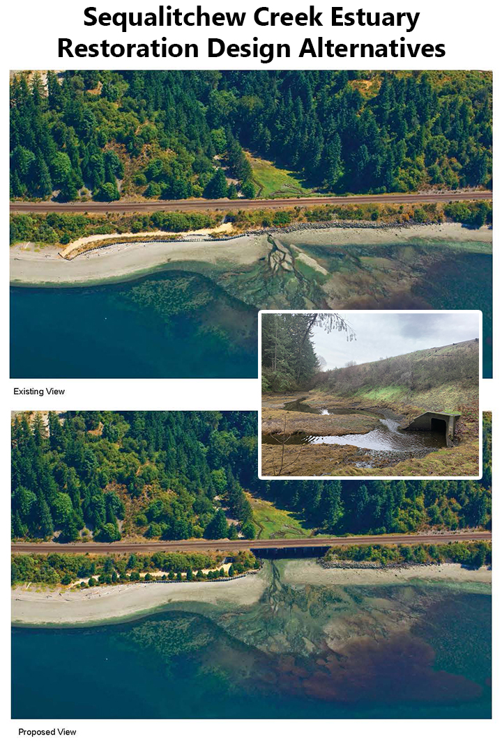
- Sequalitchew Creek Estuary Restoration Design Alternatives – Completed feasibility and analyzed design alternatives to restore Sequalitchew Creek Estuary in order to guide future restoration efforts to restore tidal connectivity and nearshore processes, improve fish passage through 5’x5′ box culvert, and improve habitat conditions of the current 1-acre pocket estuary (2020)

- South Prairie Creek Watershed Catalog – [in progress] Identified and designed protection and restoration actions for the lower 15.5 miles of South Prairie Creek and the lower 6 miles of Wilkeson Creek to create and maintain critical habitat functionality, thermal diversity, hydrologic stability, and geomorphic structure to support all life stages of salmonids (2021)
- Greenwater River Restoration (RM 3.8-4.0) – [in progress] Restored instream complexity and floodplain connectivity by removing fill and armor from former rods and bridge crossings and installing 6 mid-channel wood structures and create 6 associated pools (2021)
- Middle Ohop Valley Restoration Design – Produced preliminary designs for two work sites within RM 4-5.3 of Ohop Creek that included side channel and main channel enhancements, covered pools, placed wood elements, and riparian and floodplain planting treatments (2021)

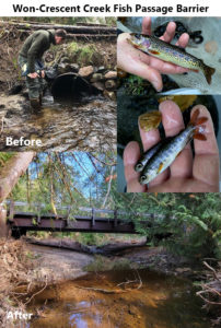
- Won-Crescent Creek Fish Passage Barrier – Replaced a partial barrier culvert that had repeatedly flooded the landowner’s driveway and created headwall erosion with a 50’ft spanning bridge to restore complete fish passage through the crossing; reconfigured 150-ft of stream channel to mitigate erosion, and added large wood habitat structures, making 1-mile of high quality stream habitat available for adult and juvenile salmonids (2021)
- Mashel River Habitat Designs RM 0-3 – [in progress] Designed two adjacent restoration areas at the mouth of the Mashel River where bridge abutments, bank armoring, and fill will be removed to restore floodplain and side channel connections; created a reach-scale design alternatives for the lower three miles of the Mashel River will include a field assessment of in-stream habitat and wood loading conditions to inform installation of in-stream wood to boost salmon habitat (2022)
- Caillouette-Thompson Spit Tributary-R2 – [in progress] Removed a 3-foot culvert and creek vault that is impounding a creek mouth estuary on a direct tributary to Puget Sound in Carr Inlet and replaced the culvert with a fish-passable bridge, restoring salmonid access to 0.69 miles of high quality spawning and rearing habitat as well as access to a small, forested estuary embayment (2022)
- Maas-Lacamas Creek-R19 – [in progress] Replaced a barrier culvert on Lacamas Creek, a tributary to Muck Creek in the Nisqually watershed, with a fish passable structure, restoring access to 1.23 miles of stream habitat for salmonids (2024)


* Indicates NOT a SRFB-funded project so project summary not available on RCO website
Acronyms:
FFFPP: Family Forest and Fish Passage Program
USFWS: US Fish and Wildlife Service
SRFB: Salmon Recovery Funding Board
LIP: Landowner Incentive Program
NFWF: National Fish and Wildlife Foundation
RCO: Recreation and Conservation Office
From the Mountains to the Sound
The South Puget Sound Salmon Enhancement Group helps salmon from ‘The Mountains to the Sound’. We have all seven species of Pacific Salmon throughout our service area and aim to protect all of them through habitat improvement and construction projects.
Restoration projects can include fish passage and barrier removal, floodplain and wetland reconnection, large woody debris installations, plantings, and more. With many projects combining these into a comprehensive restoration plan.
The Projects Map below shows all of SPSSEG’s projects funded through the Washington Recreation and Conservation Office (RCO).
(Some projects, including Habitat Assessment and Monitoring, with alternate funding sources may not be shown on this map)